![Guild of the Dragons -Knowledge Node [^]~~~~~Gratitude~~~~~[^] G0TD](https://guild-of-the-dragons.ghost.io/content/images/2024/02/depositphotos_1562554-stock-photo-golden-dragon.jpg)
SAHARA LOST RUINS NOW DOCUMENTED IN THIS BLOG!
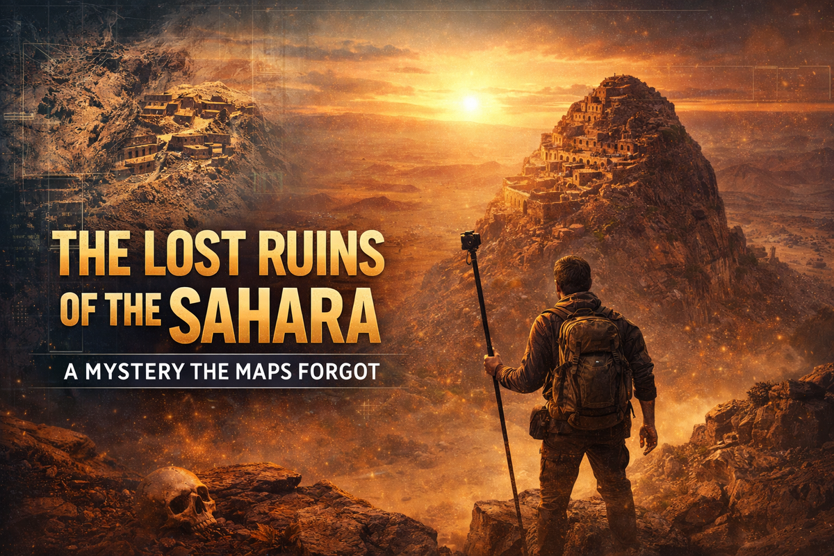
The Lost Ruins of the Sahara: A Mystery the Maps Forgot
It began the way many modern mysteries do — not with an expedition, not with a government archive, but with a cursor hovering over a screen.
While scanning satellite imagery on Google Earth, an explorer named Josh noticed something strange: a cluster of stone structures perched on an isolated rocky outcrop deep in the Sahara Desert. There were no labels. No tourist markers. No academic references. Just geometry in the dust where geometry shouldn’t exist.
Naturally, he searched.
Nothing.
No documentation. No photos. No mention in archaeological databases. Even more unsettling, he found other similar structures scattered across nearby mountaintops — all equally undocumented, all equally ignored.
A pattern without a record.
That’s when the question shifted from curiosity to mystery:
Who built these… and why has no one written about them?
Into Forbidden Territory
The coordinates led to one of the most sensitive regions in North Africa: a military-controlled border zone between Algeria and Morocco. This wasn’t just remote — it was restricted.
Undeterred, Josh traveled to Morocco and partnered with a local guide named Mustafa. Even Mustafa, born and raised in the region, had never visited these specific sites. They weren’t on maps. They weren’t on tours. They weren’t even in local stories.
Reaching the area required a two-day drive through some of the harshest terrain on Earth. The journey crossed the snow-covered Atlas Mountains and passed through forgotten valleys where time seemed to fold in on itself.
Along the way, they stumbled upon an 18th-century mud fortress belonging to the Glowi family — legendary traders whose wealth once rivaled kings.
Here, salt was life.
In ancient Morocco, one kilogram of salt was traded for one kilogram of gold. Roman workers demanded their wages in salt — giving birth to the very word salary. Camel caravans from as far as China once passed through these lands, carrying silks, spices, and secrets across continents.
The Sahara wasn’t empty.
It was once the bloodstream of civilization.
The World’s First Bank
Mustafa eventually led Josh to a hidden place known only to a few locals — Tazak, meaning “The Strong Place” in the Berber language.
Carved into a sheer cliffside, Tazak looked like something out of myth: dozens of man-made holes tunneling into stone, forming a massive underground storage complex.
This wasn’t a temple.
This was a bank.
For over 3,000 years, Berber families stored grain, wheat, and valuables inside these cliff chambers. Each family had its own room — a literal ancient savings account. Wealth was measured not in coins, but in how deep your room went into the mountain.
Some chambers were larger than others.
Which meant someone, even back then, was very rich.
These granaries existed from around 1000 BC until the 1800s — a financial system older than most modern nations.
And here’s where the mystery deepens…
Not all granaries were in cliffs.
Some were built on mountaintops.
The Site No One Was Allowed to See
As Josh and Mustafa approached the original Google Earth coordinates, the atmosphere changed. Military signs appeared. A truck stopped them. Questions were asked.
They were escorted to a barracks.
Permission to proceed was denied.
The ruins lay beyond the border — in forbidden territory.
So Josh made a decision.
Plan B.
Another site. Similar structure. Same patterns. But located just far enough from the military zone to attempt on foot.
Alone.
No drones. No trails. No online records. Just satellite coordinates and a dried riverbed cutting through rock.
What he found was staggering.
A Fortress Above Time
The mountain was nearly vertical. No modern path. No signage. But wrapping around the summit was a massive stone wall — still standing after thousands of years of desert wind.
Inside were dozens of outlined stone rooms connected by narrow pathways.
The layout matched Tazak exactly.
Storage-sized chambers. Defensive position. Strategic viewpoint over ancient trade routes.
But unlike known Berber sites…
This one had no name.
No carvings.
No history.
If the ruins were built when the Sahara was still green — when rivers flowed and lakes existed — they could date back over 5,000 years.
That would place them before nearly all known North African structures.
Before recorded Berber settlements.
Before documented civilization in the region.
Theories from the Edge
What was this place?
A fortified village?
A secret granary?
A caravan taxation fortress?
A temporary refuge during tribal wars?
A lost civilization erased by climate change?
The rooms match granary dimensions.
The location matches trade routes.
But the absence of water sources breaks traditional patterns.
Which leads to the most unsettling conclusion:
We are missing chapters of human history.
Not destroyed.
Just… never written.
The Real Mystery
The Sahara today feels empty.
But 5,000 years ago it was lush, green, alive.
Civilizations don’t vanish — they migrate, collapse, adapt, or get buried.
And some leave behind structures that maps forget.
This site — and others like it — suggest an entire network of ancient systems we’ve never cataloged. A civilization that managed wealth, protected resources, and engineered stone fortresses in a land that is now uninhabitable.
The ruins are still there.
Waiting.
Not for archaeologists.
But for someone curious enough to look at the Earth from above and ask:
What else have we missed?
A Call to the Mystery Community
This isn’t just Josh’s story.
It’s an invitation.
An invitation to:
- Re-examine satellite imagery.
- Question official maps.
- Explore forgotten geography.
- Document what institutions ignore.
Because history isn’t finished.
It’s just incomplete.
And somewhere in the dust of the Sahara, a civilization that once mastered survival in a green world is still whispering through stone:
“We were here. You just forgot to look.”